SoilCap.html
Soil capabilityprogramme usingLand-capability-classification system of the USDA
Dorronsoro B., García I., Dorronsoro-Diaz C., Diez M., Santos, F., Dorronsoro-Fdez C.
As it is well known, soil is a component of the natural medium that acquires its morphology and properties after a long and slow evolution and after reaching equilibrium with environmental conditions. It is, then, a natural entity, which does not anticipate human use in its evolution. Nevertheless, ever since humans during the Neolithic shifted from hunting and gathering to farming and herding, the soil has undergone intensive exploitation. Some 10,000 years of irrational soil use by humans has transpired, with no objective beyond seeking maximum yield from every kind of soil use. As a result, the soil has reached the present day intensely degraded to the point that a great part of arable land, especially in arid and semiarid regions, is in a situation of irreversible deterioration. To stop this dramatic trend, the only solution is to institute rational soil use—that is, to use each soil in a way that best suits its characteristics and to programme its management for minimal degradation. This is precisely the final aim of land evaluation.
Land evaluation is an applied classification system that assesses the capacity of the soil for its optimal use—that is, to derive maximum benefits with minimum degradation. This can be defined, according to van Diepen et al. (1991), as “any method to explain or predict the use potential of land”.
Different types of soils present widely different properties, and therefore the response to each use differs. Land evolution is based on the idea that this response is a function of these properties, and, hence, knowing these, we can predict the behaviour of the soil under a given use. From the study of such properties, different degrees of suitability of the soil can be inferred for each end proposed.
As land evaluation is intended to offer practical results that can be plotted on territorial maps, such endeavours cannot be limited to the analysis of the physical medium of the earth, but rather must be complemented by the corresponding socio-economic studies that enable cost-benefit analyses of the profitability of the land used. Thus, land evaluation enables predictions on the biophysical and economic behaviour of land for current and potential uses.
The application
This computer program shows how to evaluate soils for Land Capability according to the Land-capability-classification system of the USDA (Montgomery and Kieberg, 1965), but as politico-socio-economic criteria are not employed, the Soil Evaluation term proposed by Dorronsoro (2002) instead of Land Evaluation have been used. Soil evaluation represents the first step for land evaluation; soil evaluation would be similar to land evaluation, but excluding all social, economic and political characteristics.
It is a application with educational purposes to introduce the students in the soil evaluation techniques.
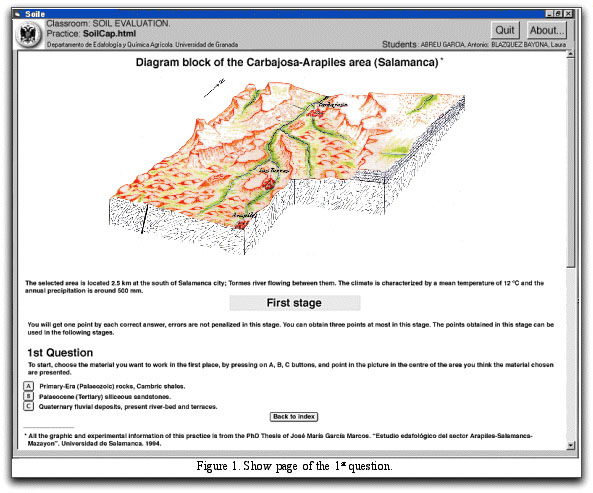
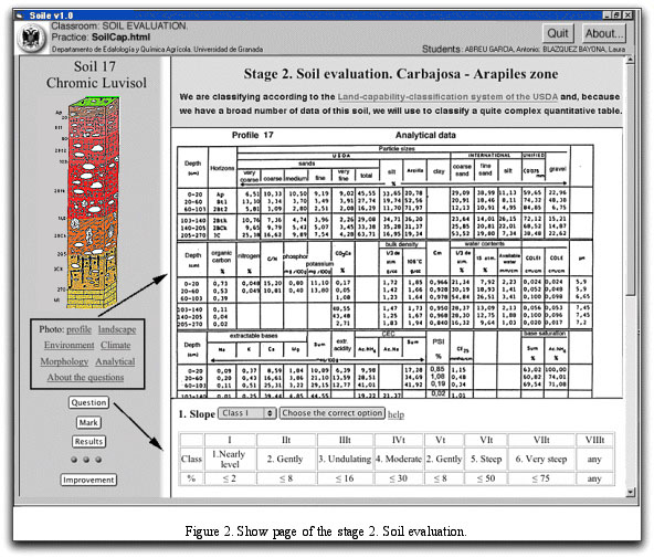
Each area to evaluate is represented in a diagram block. The program is organized in three stages. In the first stage three questions about the soils are established, their location and forming factors. In this previous stage bonus can be obtained to compensate for the possible mistakes in the final stage of the soil evaluation. In the second stage, for each soil, data are provided in relation to the general characteristics of the zone where the soil is located (climate and morphological as well as physico-chemical data) together with a photograph of the profile and landscape in question.
For the soil evaluation, a series of questions are posed concerning: 1) slope of the terrain; 2) soil depth; 3) rock content; 4) rock and gravel content; 5) drainage; 6) flood risk; 7) texture; 8) pH; 9) degree of base saturation; 10) carbonate content; 11) salt content; 12) climatic aridity; 13) frost risk; 14) degree of erosion (Figure 2).
To define the use capacity degrees for the several evaluator parameters data of Dorronsoro (2002) have been used.
In the third stage prescription-of-use map of the evaluated soils is made.
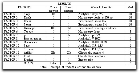
The program allows both the self-learning of the students as their self-evaluation. The highest score is 10 points, each wrong answer being penalized two points (Table 1).
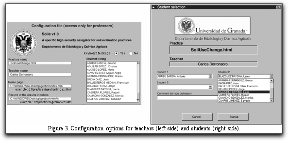
The structure of this program is multi-platform (PC, Mac, Linus, etc.); it is written in html/JavaScript. A specific high-security navigator (Soile) has been developed to examine students (Figure 3), by cancelling some non-desired options of the usual navigators (navigator menu, refresh of the page, access to the source, access of the historical, etc) and providing automatic recording of the results.
References
Dorronsoro, C. 2002. Soil evaluation. The role of the Soil Science in the Land Evaluation. Sustainble use and management of soils in arid and semiarid regions. SUMASS 2002.Cartagena (Murcia-Spain).Volume I. Edts.: A. Faz, R. Ortiz, A.R. Mermut. 106-128. Quaderna Editorial. Murcia. Klingebiel, A.A. & Montgomery, P.H. 1961. Land capability classification. USDA Agricultural Handbook 210. US Government Printing Office, Washington, DC.
van Diepen, C.A., Van Keulen, H., Wolf, J. & Berkhout, J.A.A. 1991. Land evaluation: from intuition to quantification. In: Advances In Soil Science (ed. B.A. Stewart). Springer, New York, pp. 139-204.