SoilUseChange.html
Dorronsoro-Diaz C., Martinez F.J., Martin F., Dorronsoro B., Simon M., Fernandez E., Dorronsoro-Fernandez C.
Introduction
The globalization of the world makes the demands of the society modify quickly and the agricultural productions were involved in few predictable changes. Very cost-effective crops today will give up in short-term. The changes in soil use produces uncertainty in the farmer because he knows the behaviour of his soils to the crops used, but ignore their capacity for new crops. In these cases, land evaluation represent an efficient help, advising and avoiding serious losses by the selection of mistaken uses.
Different types of soils present widely different properties, and therefore the response to each use differs. Land evolution is based on the idea that this response is a function of these properties, and, hence, knowing these, we can predict the behaviour of the soil under a given use. From the study of such properties, different degrees of suitability of the soil can be inferred for each end proposed.
As land evaluation is intended to offer practical results that can be plotted on territorial maps, such endeavours cannot be limited to the analysis of the physical medium of the earth, but rather must be complemented by the corresponding socio-economic studies that enable cost-benefit analyses of the profitability of the land used. Thus, land evaluation enables predictions on the biophysical and economic behaviour of land for current and potential uses.
As is well known, the olive orchard is an erosive crop in which the economic profitability depends on subsidies from the EU. The soil of a large part of Andalusia (southern Spain) are completely eroded due to the extensive cultivation of the olive. Therefore, it would be desirable to change some this land to another type of use that would be less erosive and more profitable.
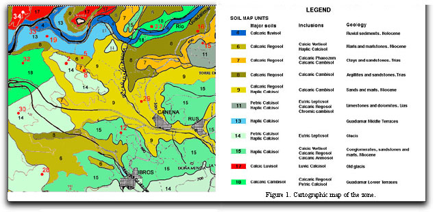
The study area is the region of La Loma (Jaén); particularly the sector between Linares and Baeza, in the southern side of the Guadalimar river. It is located in the Guadalquivir river basin, inside the Betic Chain. The litology is dominated by carbonate materials, mainly marls, marly limestones, calcaric sandstones and limestones. The relief is hilly with smooth and moderate slopes. Guadalimar river has a sequence in bad preserved steppy terraces (Delgado, 1983; Marañés, 1997; Simón, 1997).
The application
This communication concerns the trails of use change in an olive-growing zone to other crops by means of the system “A framework for land evaluation (FAO, 1976)”. The tested crops are: almond tree, pistachio, cherry tree, vineyard, chickpea, sunflower, wheat, potato and aromatic plants (Satureja cuneifolia, Acinus alpinus, Lavandula latifolia, Lavandula lanata, Sideritis funkiana, Sideritis hirsuta, Thymus zygis y Salvia lavandulifolia).
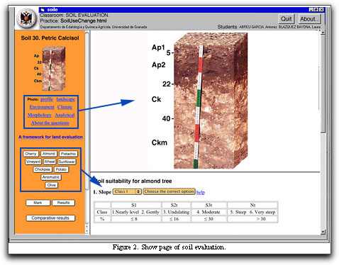
Soil evaluation is presented in an interactive way by a computer program in such a way that it can be used as a learning tool by students in classes on Land Evaluation.
For each soil, data are provided in relation to the general characteristics of the zone where the soil is located (climate and morphological as well as physico-chemical data) together with a photograph of the profile and landscape in question, represented on a map of the corresponding cartographic unit.
The soil evaluation is made after answering a total of 20 questions on soil characteristics: 1) slope of the terrain; 2) soil depth; 3) rock content; 4) rock content; 5) gravel content; 6) drainage; 7) Organic carbon; 8) texture of the surface horizon; 9) texture of the subsurface horizon; 10) pH of the surface horizon ; 11) pH of the subsurface horizon; 12) degree of base saturation of the subsurface horizon; 13) base saturation degree of the subsurface horizon; 14) carbonate content of the surface horizon; 15) carbonate content of the subsurface horizon; 16) salt content of the surface horizon; 17) salt content of the subsurface horizon; 18) sodium content of the surface horizon; 19) sodium content of the subsurface horizon; 20) degree of erosion.
The correlation matrix necessary to calculate the aptitude degrees of the several crops have been defined using data of Martínez (1990), Sys et al. (1993) y Marañes (1997).
As politico-socio-economic criteria are not employed, the Soil Evaluation term proposed by Dorronsoro (2002) instead of Land Evaluation have been used. Soil evaluation represents the first step for land evaluation, soil evaluation would be similar to land evaluation, but excluding all social, economic and political characteristics.
The application allows both the self-learning of the students as their self-evaluation.The highest score is 10 points, each wrong answer being penalized two points.
The structure of this application is multi-platform (PC, Mac, Linus, etc.); it is written in html/JavaScript. A specific high-security navigator (GsuelosExplorer) has been developed to examine students, by cancelling some non-desired options of the usual navigators (navigator menu, refresh of the page, access to the source, access of the historical, etc) and providing automatic recording of the results.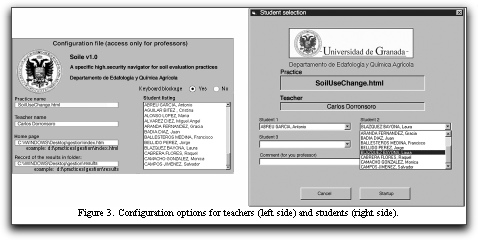
References
Delgado G. 1983. Estudio edáfico de la zona de Linares. Capacidad de uso de los suelos. Tesis Doctoral. Universidad de Granada.
Dorronsoro C. 2002. Soil evaluation. The role of the Soil Science in the Land Evaluation. Sustainble use and management of soils in arid and semiarid regions. SUMASS 2002.Cartagena (Murcia-Spain). Volume I. Edts.: A. Faz, R. Ortiz, A.R. Mermut. 106-128. Quaderna Editorial. Murcia.
FAO. 1976. A framework for land evaluation. Soils Bulletin 32. Rome. Italy.
Marañés A. 1997. Suelos de olivar de La Loma (Jaén). Tesis Doctoral. Universidad de Granada.
Martinez F.J. 1990. Estudio edáfico de la hoja de Guadix (1.001). Evaluación y uso de los suelos. Tesis Doctoral: Universidad de Granada.
Simón M., Marañés A., García I., Asensio C., Iriarte A. 1997. Mapa de suelos 1:100.000. Úbeda-906. Proyecto LUCDEME. Ministerio de Medio Ambiente y Universidad de Granada.
Sys, C., Van Ranst, E., Debaveye, J. & Beernaert, F. 1993. Land evaluation. Part 3: Crop requirements. Agricultural Publications 7. General Admin. Develop. Coop., Brussels.