Soil evolution over the Quaternary period in a Mediterranean climate (SE Spain)
I. Ortiz, , M. Simón, C. Dorronsoro, F. Martín and I. García
Departamento Edafología y Química Agrícola, Facultad de
Ciencias, Universidad de Granada, Campus de Fuentenueva, s/n 18071, Granada,
Spain
1. Introduction
2. Site details
3. Materials and methods
4. Results
4.1. Macromorphology
4.2. Analytical features
4.3. Micromorphological features
5. Discussion
5.1. Buried soils
5.2. Surface soils
5.3. Soil–time relationships
6. Conclusions
Acknowledgements
References
According to Jenny (1941), soils and their properties are the product of the
different soil-forming factors (climate, organisms, relief, parent material
and time) that control the degree of soil development, as indicated by comparisons
with the parent material (Harden, 1990). Because the soil-forming factors also
govern geomorphic processes, landscape evolution is intimately related to soil
development (McFadden and Kneupfer, 1990).
Over time, soil-forming factors, especially climate and vegetation, may change
in such a way that many old soils, palaeosols, are not related to the present
climate and vegetation. Palaeosols, defined as soils formed in a landscape of
the past (Ruhe and Yaalon), include both relict and buried soils (Bronger and
Catt, 1989). Relict soils are surface soils which show inactive characteristics
inherited from past periods when soil-forming conditions were sufficiently different
from those of the present to produce features unlike any of those developing
currently in the same area. They are likely to have properties similar to those
of buried soils that formed during the same past periods (Catt, 1989). It is
possible to reconstruct relief and/or palaeoclimate as soil-forming factors
on the basis of the processes inferred from palaeosol properties (Bronger and
Catt, 1989).
Properties of the different soil horizons have also been used to determine the
age of soils (Harden; Levine and Harrison) and thus the approximate age of the
landforms (Semmel, 1989). For this reasoning to be valid, climatic conditions
must remain relatively stable over the entire soil-forming period, for only
then do the soil properties increase constantly with time (Bockheim and Birkeland).
However, dating becomes complex on surfaces subject to long-term climatic fluctuations.
This can be solved if relationships between specific soil properties and climatic
fluctuations are known.
Among soils up to 85,000 years old (estimated from the clay accumulation index
of Levine and Ciolkosz, 1983) in Sierra Nevada (SE Spain), Simón et al.
(2000) distinguished two well-differentiated groups: (a) soils approximately
85,000 years old (early Late Pleistocene), with strongly developed Bt horizons,
which are red in colour, clayey in texture and contain abundant clay coatings
and much kaolinite; and (b) soils younger than 15,000 years (Late Pleistocene–Holocene),
with less developed Bw horizons, which are brown in colour, without evidence
of clay illuviation and with small kaolinite contents. The degree of development
of the latter group was less in the younger surface. No soils of intermediate
ages (between 85,000 and 15,000 years old) were found, apparently because of
unstable surfaces and a cold climate during this time interval, which would
have discouraged chemical weathering and soil development (Catt, 1989). In Sierra
Nevada, SE Spain, some surfaces older than 85,000 years are preserved, probably
formed during the Riss glacial period (Hempel; Messerli and Lhenaff), but their
soils are strongly eroded and cannot be used for determining soil–time
relationships. However, lower elevation alluvial fan deposits around Sierra
Nevada that resulted from the tectonic activity in the Late Pliocene exhibit
stable surfaces with soils of Early Pleistocene age (Estévez and Sanz
de Galdeano, 1983). Also, the reorganization of the relief during the Middle–Late
Pleistocene formed unstable surfaces on which successive depositional episodes
alternated with pedogenic episodes (Sanz de Galdeano and López-Garrido,
1999).
In this paper, we compare soil development on two different types of surfaces
in SE Spain: (1) geomorphically stable surfaces with old soils also showing
younger pedogenic overprinting (surface soils) and (2) unstable surfaces with
successive erosion–deposition episodes, forming sequences of buried soils
in which the successive pedogenic stages are spatially distinct. The aim is
to reconstruct soil development over the Quaternary period in a Mediterranean
climate.
The Granada Basin is located in the central sector of the Betic Cordillera (SE
Spain) in the contact area between the External and the Internal Zones (Fig.
1). The External Zones, located to the north of the Granada Basin, are made
up of Mesozoic and Tertiary carbonate rocks (limestones and dolomites). The
Internal Zones, located to the east of the Granada Basin, are made up of two
complexes: the Nevado–Filabride Complex, occupying the central sector
of Sierra Nevada and composed mainly of mica schists and quartzites; and the
Alpujarride Complex, forming a ring around Sierra Nevada and composed of phyllites,
quartzites, limestones and dolomites. During the Late Miocene, Sierra Nevada
was strongly uplifted whereupon massive erosion gave rise to major alluvial
fans containing large blocks reworked from the Nevado–Filabride Complex
on the borders of the basin, and lacustrine formations were deposited in subsiding
areas within the basin (Fernández and Soria, 1986–1987). In the
Late Pliocene, there was renewed uplift (Estévez and Sanz de Galdeano,
1983), and significant new coarse detrital inputs from the External and the
Internal Zones were deposited in the basin during the Early Pleistocene. Consequently,
the northern half of the basement of the Granada Basin is made up of Mesozoic
and Tertiary carbonate materials from the External Zones, and the eastern half
consists of Paleozoic and Triassic materials from the metamorphic complexes
of the Internal Zones (Fernández et al., 1996). Further reorganization
of the relief occurred during the Middle?–Late Pleistocene. Low areas
on the borders of Sierra Nevada rose and subsequent erosion episodes, probably
activated by cold episodes, have left behind abundant coarse-grained deposits.
In summary, the uplift of Sierra Nevada and the different sedimentation episodes
in the Granada Basin were not continuous processes but resulted from pulses
of tectonic activity separated by periods of relative quiescence (Sanz de Galdeano
and López-Garrido, 1999).
The present climate of the area (Table 1) is typically Mediterranean (hot, dry summers; cold, wet winters; temperate autumns and springs with variable rainfall). The natural vegetation (Valle and Ruiz) is oak forest (Quercus rotundifolia) with shrubs (Juniperus oxycedrus, Ruscus aculeatus, Daphne gnidium, Clematis flammula, Lonicera etrusca and Hedera helix) and herbaceous plants (Paeonia coriacea, P. broteroi, Primula vulgaris and Viola sp.). However, in many sectors, this has been replaced by crops such as olive and almond trees.
We have studied soils that developed on three alluvial fans in the Granada Basin
that have remained relatively stable over time (Fig.
1). Two of these, Dúrcal (DUR) and Llano de la Perdiz (LLP), date
from the Early Pleistocene (Aguirre; Ruiz and Sanz), and consist of gravels
with mica schists and quartzites from the Nevado–Filabride Complex and
a small proportion of limestones and dolomites from the Alpujarride Complex.
The third alluvial fan, Colomera (COL), also dates from the Early Pleistocene
(Fernández and Soria, 1986–1987) but has gravel clasts of limestones
and dolomites from the External Zones.
Similarly, in a sector adjacent to the area that rose during the Middle?–Late
Pleistocene, Nigüelas (NIG), we studied a vertical section approximately
11.5 m high where four depositional episodes of gravelly materials, equivalent
to those from DUR and LLP (mica schists and quartzites from the Nevado–Filabride
Complex with a small proportion of limestones and dolomites from the Alpujarride
Complex), were distinguished. These depositional episodes alternated with pedogenic
episodes. We identified and studied four buried soils and designated them (from
bottom to top) as NIG-1, NIG-2, NIG-3 and NIG-4 (Fig.
2). The original surfaces of soils NIG-1 and NIG-2 were tilted before the
deposition of the parent material of soil NIG-3.
Field descriptions of the soils were based on procedures of the Soil Survey Staff (1990). The micromorphological study was based on thin sections (Bullock et al., 1985). The Munsell soil colour chart was used to describe the soil colours. Particle size distribution was determined by the pipette method after the removal of organic matter with H2O2 and dispersion by shaking with sodium hexametaphosphate (Loveland and Whalley, 1991). The organic carbon content was determined using the method of Tyurin (1951). The pH was measured potentiometrically in a 1:2.5 soil/water suspension. The CaCO3 equivalent was determined according to Williams (1948). For the determination of the cation exchange capacity (CEC), 1 N Na–acetate was used at pH 8.2. Exchangeable bases were extracted with 1 N NH4–acetate at pH 7.0 and measured by atomic absorption spectroscopy (Ca and Mg) and flame photometry (Na and K). Discs of soil and lithium tetraborate (0.6:5.5) were prepared and the total contents of Si, Fe and Al were measured by X-ray fluorescence using a Philips PW-1404 instrument. X-ray diffraction patterns for the clay fraction were obtained with a Philips PW-1700 instrument using CuK radiation, and the diffraction intensities used in the quantitative analysis were taken from Schultz (1964) and Barahona (1974). Total iron oxides (Fed) were extracted with citrate–dithionite (Holmgren, 1967), and the amorphous forms (Feo) with ammonium oxalate (Schwertmann and Taylor, 1977). Iron in the extracts was measured by atomic absorption spectroscopy. A redness index (Rr) was calculated as (hueÅ~chroma)/value (Hurst, 1977). For this index, hue is converted to the following values: 10YR=0.0, 7.5YR=2.5, 5YR=5.0, 2.5YR=7.5 and 10R=10.0.
To estimate the degree of development of each profile, a clay accumulation index
(CI) was calculated as (B-C)T, where B=B horizon clay content (%), C=C horizon
clay content (%) and T=thickness (cm) of the B horizon (Levine and Ciolkosz,
1983). Similarly, an iron oxide accumulation index (FedI) was calculated using
the same equation as for the clay, where B=B horizon Fed content (%) and C=C
horizon Fed content (%). To estimate the age of the soils, the equation of Levine
and Ciolkosz (1983) was used:
log(year)=1.81+0.998Å~log(CI)
The C horizons of all the soils ranged in colour from pink to light brownish
grey and retained the original deposit structure although in the surface soils,
the mineral particles are cemented by calcium carbonate. None of the buried
soils contains a clear A horizon, suggesting that they were disturbed or truncated
at the time of burial. Surface soils also seemed to be truncated, especially
soils COL (under olive cultivation) and DUR (under almond cultivation), where
the Ap horizons are part of the previous Bt horizons that are disturbed by ploughing.
Soil LLP was the least disturbed. All soils have a well-developed Bt horizon
(Table 2) characterized by a red colour
and a moderate to strong angular–subangular blocky or prismatic structure.
The redness indices of the most strongly developed Bt horizons in each soil
ranged from 7.5 to 15, being greatest in the surface soils COL, LLP and DUR
and the buried soil NIG-3, intermediate in soils NIG-1 and NIG-2 and least in
NIG-4.
All the Bt horizons contained more clay than the C horizons (Table
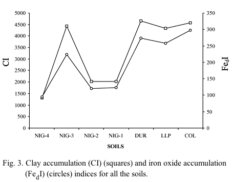
3). The clay accumulation index (CI) was greatest in soils COL, DUR, LLP
and NIG-3, intermediate in soils NIG-1 and NIG-2, and least in soil NIG-4 (Fig.
3). The pH in the Bt horizons was mostly alkaline (Table
3) except for soil LLP, where slightly acid pH values appeared in the upper
weakly calcareous horizons. In soil NIG-2, the Bt horizons seem to have been
recalcified by the leaching of calcium carbonate from soil NIG-3. CaCO3 has
accumulated in the Ck horizons, particularly in the surface soils where the
mineral particles are cemented to form a Ckm horizon. For this reason, they
could be designated as Bk or Bkm, but because most or all of the original parent
material structure has not been obliterated (Soil Survey Staff, 1990), they
are labelled as C horizons. The gravel content was similar in all C horizons
(Table 3). The Bt horizons of all the
soils contained very little organic C, indicating that the mineralization of
organic matter predominated during the development of these soils.
The cation exchange capacity (CEC) was related to the clay and organic C contents by the multiple-regression equation:
CEC (cmolc kg-1)=5.008Å~OC (%)+0.345Å~ Clay (%) (r=0.965)
The regression coefficients show that the influence of organic C on the CEC
values was roughly 15 times greater than that of the clay. Exchangeable bases
are dominated mainly by Ca2+ and Mg2+, with lesser amounts of Na+ and K+. Only
the Ap horizons of soils DUR and COL show relatively high contents of K+ which
is attributable to fertilizing. All soils are eutric. The high base saturation
(equal or close to 100%) can be attributed to basification by the runoff of
waters rich in Ca2+ and Mg2+ originating from the surrounding terrain of limestone
and dolomite. Only soil LLP, whose surface was isolated from the surrounding
terrain by an incision of the rivers probably during the Middle?–Late
Pleistocene (Sanz de Galdeano and López-Garrido, 1999), was less affected
by this runoff and has a base saturation of less than 80% in its upper horizons.
This basification must have occurred subsequent to soil formation and the original
pH of the Bt horizons should have been more acidic than that at present. The
neutral or nearly neutral pH values and high base saturation of these red soils
have also been explained by the occurrence of dry periods during which there
was a capillary rise of bases (Lamouroux, 1971). Whatever the mechanism causing
basification, the red soils are usually less acidic than the brown soils that
developed over the similar parent material (Duchaufour, 1977).
The contents of the total iron (Fet) that was extracted by dithionite (Fed)
and that extracted by oxalate (Feo) were all greater in the Bt horizons than
the C horizons (Table 4). The values
of the iron oxide accumulation index (FedI) showed a similar pattern to those
of the clay accumulation (Fig. 3) and
redness indices (Fig. 4). It was greatest
in the Bt horizons of soils COL, LLP, DUR and NIG-3, least in soil NIG-4 and
intermediate in soils NIG-1 and NIG-2. The values of the Feo/Fed ratio in the
Bt horizons were very small (<0.05), indicating an almost total crystallization
of the hydrous Fe oxides that were formed by the weathering of silicates (Arduino
et al., 1986).
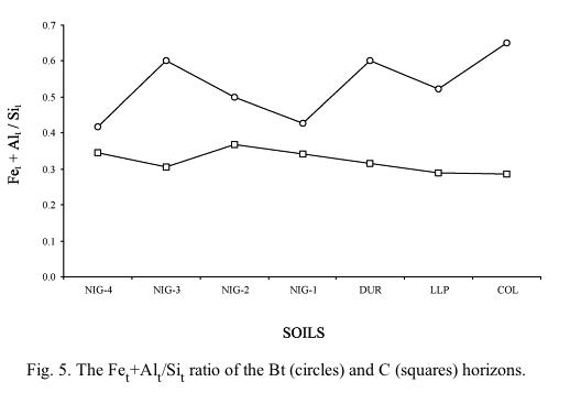
In all the soils, the Fet/Sit and Alt/Sit ratios were greater in the Bt horizons than the C horizons (Table 4), indicating that Si was more mobile than Fe and Al. As the original pH of these soils should not have been <5.0 (Loughnan, 1969), the difference in the Fet+Alt/Sit ratio between the Bt horizons and C horizons should increase with greater weathering and leaching. These differences show approximately the same patterns as the CI, FedI and Rr indices (Fig. 5).
The semi-quantitative analysis of the clay minerals (Table 4) also revealed differences between the soils. In soils COL, LLP, DUR and NIG-3, smectite is less abundant and kaolinite was more abundant in the Bt horizons than in the C horizons. However, in soils NIG-1, NIG-2 and NIG-4, the upward increase in kaolinite was weaker than in other soils. The kaolinite neoformation in the Bt horizons must have occurred before basification when the soils were more acidic.
4.3. Micromorphological features
The Bt horizons show a porphyric-related distribution, with stipple-speckled
b-fabric in soils NIG-1, NIG-2 and NIG-4 and mono-granostriated b-fabric in
NIG-3 and the surface soils. In NIG-4, the Bt horizons show many thin red clay
coatings in the channels and other voids (Fig.
6a). They are somewhat thicker and more common in NIG-1 and NIG-2 (Fig.
6b), and even thicker and more abundant in NIG-3 and in the surface soils
(Fig. 6c). The surface soils contain
many fragments of these red clay pedofeatures embedded in the matrix (Fig.
6d). The red clay coatings in soil LLP have scattered yellowish zones (Fig.
6e), indicating weak hydromorphic iron depletion. Distinct and rather frequent
calcitic coatings appear in the Bt horizon of NIG-2 (Fig.
6f). Similar features also appear, though with less clarity and less frequency,
in the surface soils.
The main pedogenic processes that affected these soils were the mineralization
of organic matter, leaching of carbonates, strong weathering of smectite to
kaolinite, clay illuviation and rubification, which formed strongly developed
red Bt horizons of clay texture with abundant clay coatings. These soil properties
must have developed under a wetter climate than that at present. In addition,
the pH>7.0, the high contents of exchangeable bases and the presence of CaCO3
in the Bt horizons suggest subsequent calcification, the latter also being evident
in the micromorphological study of soils NIG-2, DUR and COL.
Continuous deep oceanic sedimentary records can be used as a chronological and
paleoclimatic reference for long-term climatic fluctuations (Kukla and Bradley).
Because the oxygen isotopic record of the oceanic sequences provides an integrated
summary of global ice-volume changes, it has been argued that the isotopic stages
should be used as standard reference units for both marine and terrestrial deposits
(Shackleton and Opdyke, 1973). Various authors have used this marine record
to date and correlate the episodes of soil development (Bronger; Bronger; Bronger;
Markewich; Stremme; Olsen; Frechen; Dearing and Antoine).
According to the ages of the isotopic events in the low-latitude oxygen-isotope
sequence (Bassinot et al., 1994), the deposit on which the heavily eroded soil
NIG-5 developed probably formed during the last cold episodes between 11,000
and 71,000 BP (stages 4–2). Consequently, the parent material of soil
NIG-4 should have formed in the former cold episode, between 127,000 and 186,000
BP (stage 6), and soil NIG-4 during the warm periods between 71,000 and 127,000
BP (stage 5). In addition, the formation of soil NIG-4, estimated by the clay
accumulation index (Levine and Ciolkosz, 1983), must have begun around 85,000
BP or even earlier, given that erosion decreased the thickness of the Bt horizons.
This supports the suggestion that this soil was formed during stage 5. The deposit
on which soil NIG-3 developed probably formed during the cold episode between
242,000 and 301,000 BP (stage 8) and soil NIG-3 during the warm episode between
186,000 and 242,000 BP (stage 7). The Bt horizons of soil NIG-2 probably formed
during the warm period between 301,000 and 334,000 BP (stage 9) and its parent
material dates from the cold episode between 334,000 and 364,000 BP (stage 10).
Finally, soil NIG-1 probably formed during the warm period between 364,000 and
427,000 BP (stage 11) and its parent material was probably deposited during
the cold episode between 427,000 and 474,000 BP (stage 12). Consequently, the
tilting of both deposits and soils NIG-2 and NIG-1, which were related to an
uplift of Sierra Nevada, must have occurred around 300,000 BP in the Middle
Pleistocene.
Based on the CI and FedI indices (Fig. 3),
the differences in the Fet+Alt/Sit ratio between Bt and C horizons (Fig.
5), the extent of kaolinite neoformation (Table
4) and the micromorphological features, soils NIG-2 and NIG-1 show similar
degrees of development although less than that of soil NIG-3 and greater than
that of NIG-4. In addition, the duration of the warm periods in which these
soils developed was around 63,000 years (NIG-1), 33,000 years (NIG-2) and 56,000
years (NIG-3 and NIG-4). Therefore, the time factor appears not to account for
the different degrees of development of the buried soils, especially NIG-1,
NIG-3 and NIG-4. The greater development of soil NIG-3 may therefore be attributed
to a different, probably moister, climate. Greater moisture would also account
for the leaching of carbonates from the Bt horizons of NIG-3 through the C horizon
to form calcitic coatings in the Bt horizons of soil NIG-2. Consequently, in
our region, the different degrees of soil development during the last 474,000
BP indicate that the wettest climate of the later Quaternary warm periods dates
from between 186,000 and 242,000 BP (stage 7), and the driest from 71,000–127,000
BP (stage 5). The warm periods older than 242,000 BP (stages 9 and 11) probably
had climates with intermediate wetness.
The parent materials of the surface soils, dating from the Early Pleistocene
(between 788,000 and 1,650,000 BP; Birkeland, 1999), must have been deposited
during one of the cold episodes before 788,000 BP, and the soils on them were
formed during subsequent warm periods. The CI and FedI indices (Fig.
3), the differences in the Fet+Alt/Sit ratio between Bt and C horizons (Fig.
5), the extent of kaolinite neoformation (Table
4) and the micromorphological features were similar in all of the soils,
indicating an equivalent degree of weathering and development. The minor differences
in the indices of these soils could be attributed to parent-material differences
or to waterlogging in some profiles. The greater weatherability of carbonate
materials (limestones mainly) compared with metamorphic materials (mica schists
and quartzites) could account for the slightly stronger development of soil
COL, and the hydromorphic processes that affected soil LLP could explain its
slightly weaker development.
The extent of development of the surface soils is similar to that of NIG-3,
but the FedI index of the latter is slightly less (Fig.
3). Nevertheless, the surface soils present two basic differences from soil
NIG-3. First, most of the red clay coatings are fragmented and incorporated
into the soil matrix, and second, a strong accumulation of CaCO3 in the C horizons
cements the mineral particles, forming the Ckm horizon. The fragmentation of
the clay coatings suggests frost disturbance (Catt, 1987) and may be attributed
to the cold episodes (Kemp and Van) following the formation of the Bt horizons.
The origin of the large carbonate contents of the Ckm horizons of soils LLP
and DUR, which were formed on a parent material similar to NIG-3 and also have
decalcified Bt horizons, cannot be explained purely by leaching from the upper
horizons, rather, this carbonate content must be attributed to the infiltration
by the runoff water that is rich in Ca2+ and HCO3- ions. The presence of calcitic
coatings in the Bt horizons of the surface soils indicates recalcification after
the formation of the Bt horizons. This implies that CaCO3 accumulation and cementation
in the Ckm horizons increased over time as described in the soils of fluvial
terraces (Dorronsoro and Alonso, 1994). However, the accumulation of CaCO3 in
the Ckm horizons was far greater in COL because this soil was surrounded by
and formed over carbonate materials. Consequently, in periods after their formation,
these soils were partially truncated, disturbed and recalcified to form polygenetic
soils (Tarnocai and Valentine, 1989).
Because the extent of development of the surface soils is similar to that of
NIG-3, we cannot rule out that it occurred during stage 7. Nevertheless, it
could also have taken place during earlier warm episodes with similar climatic
conditions to stage 7, such as stages 13 (between 474,000 and 528,000 BP) and
15 (between 568,000 and 621,000 BP). Bt horizons with clay illuviation are known
to have formed elsewhere in these early interglacials (Bronger et al., 1998a).
As the CI and FedI indices, the differences in Fet+Alt/Sit ratio between Bt
and C horizons, the extent of kaolinite neoformation and the micromorphological
features of the soils formed during stage 7 (186,000–242,000 BP) are similar
to surface soils formed on deposits of the Early Pleistocene, these features
cannot be used to date surfaces older than 242,000 BP. In contrast, the degree
of development of the soils formed in stage 5 and later is less than that in
stage 7 and decreases progressively towards the youngest surfaces (Simón
et al., 2000), showing a clear relationship between the degree of development
and the age of the surfaces on which they formed. Consequently, these soils
can be used for the approximate dating of landforms.
The depositional and soil development episodes during the Pleistocene were not
continuous but were governed by pulses of tectonic uplift, giving rise to sedimentation,
separated by periods of relative quiescence with soil development. From the
Early to the early Late Pleistocene, the main pedogenic processes were the leaching
of carbonates, weathering, illuviation and rubification, but the degree of development
of the Bt horizons varied over time. The surface soils that formed over the
deposits from the Early Pleistocene show the strongest development although
in periods after their formation, they were partially truncated, disturbed and
recalcified, resulting in polygenetic soils. The different degrees of development
of the buried soils during the last 474,000 years indicate that the wettest
warm period was stage 7 (186,000–242,000 BP), and the driest, stage 5
(71,000–127,000 BP). Stages 9 (301,000–334,000 BP) and 11 (364,000–427,000
BP) had climates with intermediate wetness. Given that the CI and FedI indices,
the differences in Fet+Alt/Sit ratio between Bt and C horizons, the extent of
kaolinite neoformation and the micromorphological features of the soils that
were formed during stage 7 are similar to the surface soils that were formed
on deposits of the Early Pleistocene, these features cannot be used to date
surfaces older than 242,000 BP. However, from stage 7, the degree of soil development
progressively declines with the decreasing age of the surfaces so that these
soils can be used to estimate the age of landforms.
Acknowledgements
This study was supported by DGICYT Project No. PB96-1385.
References
Aguirre, 1957. E. Aguirre , Una prueba paleomastológica de la edad Cuaternaria
del Conglomerado de la Alhambra. Estud. Geol. 13 (1957), pp. 135–140.
Antoine et al., 2001. P. Antoine, D.D. Rousseau, L. Zöller, A. Lang, A.V.
Munaut, C. Hatté and M. Fontugne , High-resolution record of the last
interglacial–glacial cycle in the Nussloch loess–palaeosol sequences,
Upper Rhine Area, Germany. Quat. Int. 76/77 (2001), pp. 211–229. SummaryPlus
| Full Text + Links | PDF (1259 K)
Arduino et al., 1986. E. Arduino, E. Barberis, F. Ajmone Marsan, E. Zanni and
M. Franchini , Iron oxides and clay minerals within profiles as indicators of
soil age in northern Italy. Geoderma 37 (1986), pp. 45–55. Abstract-GEOBASE
Barahona, 1974. Barahona, E., 1974. Arcillas de ladrería de la provincia
de Granada: evaluación de algunos ensayos de materias primas. Tesis Doctoral,
Universidad de Granada, Spain.
Bassinot et al., 1994. F.V. Bassinot, L.D. Labeyrie, E. Vincent, X. Quidelleur,
N.J. Shackleton and Y. Lancelot , The astronomical theory of climate and the
age of the Brunhes–Matuyama magnetic reversal. Earth Planet. Sci. Lett.
126 (1994), pp. 91–108. Abstract
Birkeland, 1990. P.W. Birkeland , Soil-geomorphic research––a selective
overview. In: P.L.K. Kneupfer and L.D. McFadden, Editors, Soils and Landscape
EvolutionGeomorphology vol. 3, Elsevier Science Publishers B.V., Amsterdam,
The Netherlands (1990), pp. 207–224. Abstract-GEOBASE
Birkeland, 1999. P.W. Birkeland Soils and Geomorphology (3rd edn. ed.),, Oxford
Univ. Press, New York (1999).
Bockheim, 1980. J.G. Bockheim , Solution and use of chronofunctions in studying
soil development. Geoderma 24 (1980), pp. 71–85. Abstract-GEOBASE
Bradley, 1985. R.S. Bradley Quaternary Paleoclimatology: Methods of Paleoclimatic
Reconstruction, Unwin Hyman, Boston (1985).
Bronger and Catt, 1989. A. Bronger and J.A. Catt , Paleosols: problems of definition,
recognition and interpretation. In: A. Bronger and J.A. Catt, Editors, Paleopedology:
Nature and Applications of PaleosolsCatena Supplement vol. 16, Catena Verlag,
Cremlingen-Destedt, Germany (1989), pp. 1–7.
Bronger and Heinkele, 1989. A. Bronger and T. Heinkele , Paleosol sequences
as witnesses of Pleistocene climatic history. In: A. Bronger and J.A. Catt,
Editors, Paleopedology: Nature and Applications of PaleosolsCatena Supplement
vol. 16, Catena Verlag, Cremlingen-Destedt, Germany (1989), pp. 163–186.
Bronger et al., 1998a. A. Bronger, R. Winter and T. Heinkele , Pleistocene climatic
history of East and Central Asia based on paleopedological indicators in loess–paleosol
sequences. Catena 34 (1998), pp. 1–17. SummaryPlus | Full Text + Links
| PDF (3226 K)
Bronger et al., 1998b. A. Bronger, R. Winter and S. Sedov , Weathering and clay
mineral formation in two Holocene soils and in buried paleosols in Tadjikistan:
towards a Quaternary paleoclimatic record in Central Asia. Catena 34 (1998),
pp. 19–34. SummaryPlus | Full Text + Links | PDF (1317 K)
Bullock et al., 1985. P. Bullock, H. Fedoroff, A. Jongerius, G. Stoops and T.
Tursina Handbook for Soil Thin Sections Description, Waine Research Publications,
Wolverhampton (1985).
Catt, 1987. J.A. Catt , Effects of the Devensian cold stage on soil characteristics
and distribution in eastern England. In: J. Boardman, Editor, Periglacial Processes
and Landforms in Britain and Ireland, Cambridge Univ. Press, Cambridge, UK (1987),
pp. 145–152. Abstract-GEOBASE
Catt, 1989. J.A. Catt , Relict properties in soils of the Central and North–West
European temperate region. In: A. Bronger and J.A. Catt, Editors, Paleopedology:
Nature and Applications of PaleosolsCatena Supplement vol. 16, Catena Verlag,
Cremlingen-Destedt, Germany (1989), pp. 41–58.
Dearing et al., 2001. J.A. Dearing, I.P. Livingstone, M.D. Bateman and K. White
, Palaeoclimate records from OIS 8.0-5.4 recorded in loess–palaeosol sequences
on the Matmata Plateau, southern Tunisia, based on mineral magnetism and new
luminescence dating. Quat. Int. 76/77 (2001), pp. 43–56. SummaryPlus |
Full Text + Links | PDF (531 K)
Dorronsoro and Alonso, 1994. C. Dorronsoro and P. Alonso , Chronosequence in
Almar River fluvial-terrace soil. Soil Sci. Soc. Am. J. 58 (1994), pp. 910–925.
Abstract-GEOBASE
Duchaufour, 1977. P. Duchaufour Pédologie: 1. Pédogenèse
et Classification, Masson, Paris (1977).
Estévez and Sanz de Galdeano, 1983. A. Estévez and C. Sanz de
Galdeano , Néotectonique du secteur central des Chaînes Bétiques
(Basins du Guadix-Baza et de Grenade). Rev. Geogr. Phys. Geol. Dyn. 21 (1983),
pp. 23–24.
Fernández and Soria, 1986–1987. J. Fernández and J. Soria
, Evolución sedimentaria en el borde norte de la Depresión de
Granada a partir del Turoliense terminal. Acta Geol. Hisp. 21–22 (1986–1987),
pp. 73–81.
Fernández et al., 1996. J. Fernández, J. Soria and C. Viseras
, Stratigraphic architecture of the Neogene basins in the central sector of
the Betic Cordillera (Spain): tectonic control and base-level changes. In: P.F.
Friend and C.J. Dabrio, Editors, Tertiary Basins of Spain: The Stratigraphic
Record of Crustal Kinematics, Cambridge Univ. Press, Cambridge, UK (1996), pp.
353–365.
Frechen, 1999. M. Frechen , Upper Pleistocene loess stratigraphy in Southern
Germany. Quat. Geochronol. 18 (1999), pp. 243–269. Abstract | PDF (1122
K)
Harden, 1982. J.W. Harden , A quantitative index of soil development from field
descriptions: examples from a chronosequence in Central California. Geoderma
28 (1982), pp. 1–28. Abstract-GEOBASE
Harden, 1990. J.W. Harden , Soil development on stable landforms and implications
for landscape studies. In: P.L.K. Kneupfer and L.D. McFadden, Editors, Soils
and Landscape EvolutionGeomorphology vol. 3, Elsevier Science Publishers B.V.,
Amsterdam, The Netherlands (1990), pp. 391–398. Abstract-GEOBASE
Harrison et al., 1990. J.B.J. Harrison, L.D. McFadden and R.J. Weldon , Spatial
soil variability in the Cajon Pass chronosequence: implications for the use
of soils as a geochronological tool. In: P.L.K. Kneupfer and L.D. McFadden,
Editors, Soils and Landscape EvolutionGeomorphology vol. 3, Elsevier Science
Publisher B.V., Amsterdam, The Netherlands (1990), pp. 399–416. Abstract-GEOBASE
Hempel, 1960. L. Hempel , Límites geomorfológicos altitudinales
de Sierra Nevada. Estud. Geogr. 78 (1960), pp. 81–93.
Holmgren, 1967. G. Holmgren , A rapid citrate–dithionite extractable iron
procedure. Soil Sci. Soc. Am. Proc. 31 (1967), pp. 210–211.
Hurst, 1977. V.J. Hurst , Visual estimation of iron in saprolite. Geol. Soc.
Am. Bull. 88 (1977), pp. 174–176.
Jenny, 1941. H. Jenny Factors of Soil Formation, McGraw-Hill, New York (1941).
Kemp, 1985. R.A. Kemp , The Valley Farm soil in Southern East Anglia. In: J.
Boardman, Editor, Soils and Quaternary Landscape Evolution, Wiley, Chichester
(1985), pp. 179–196.
Kukla, 1977. G.J. Kukla , Pleistocene land–sea correlations: I. Europe.
Earth Sci. Rev. 13 (1977), pp. 307–374.
Lamouroux, 1971. Lamouroux, M., 1971. Etude des sols formés sur roches
carbonatées. Pédogénèse fersiallitique au Liban.
Thése, Univ. Estrasburg, France.
Levine and Ciolkosz, 1983. E.R. Levine and E.J. Ciolkosz , Soil development
in till of various ages in Northeastern Pennsylvania. Quat. Res. 19 (1983),
pp. 85–99. Abstract-GEOBASE
Lhenaff, 1977. Lhenaff, R., 1977. Recherches géomorphologiques sur les
cordilleres Bétiques Centre Occidentales (Espagne). Thèse, Univ.
de Lille, France.
Loughnan, 1969. F.C. Loughnan Chemical Weathering of the Silicate Minerals,
Elsevier, New York (1969).
Loveland and Whalley, 1991. P.J. Loveland and W.R. Whalley , Particle size analysis.
In: K.A. Smith and C.E. Mullins, Editors, Soil Analysis: Physical Methods, Marcel
Dekker, New York (1991), pp. 271–328.
Markewich et al., 1998. H.W. Markewich, D.A. Wysocki, M.J. Pavich, E.M. Rutledge,
H.T. Millard, F.J. Rich, Jr., P.B. Maat, M. Rubin and J.P. McGeehin , Paleopedology
plus TL, 10Be, and 14C dating as tools in stratigraphic and paleoclimatic investigations,
Mississippi River Valley, USA. Quat. Int. 51/52 (1998), pp. 143–167. Abstract
| PDF (2343 K)
McFadden and Kneupfer, 1990. L.D. McFadden and P.L.K. Kneupfer , Soil geomorphology:
the linkage of pedology and superficial processes. In: P.L.K. Kneupfer and L.D.
McFadden, Editors, Soils and Landscape EvolutionGeomorphology vol. 3, Elsevier
Science Publishers B.V., Amsterdam, The Netherlands (1990), pp. 197–205.
Messerli, 1965. B. Messerli Beiträge zur Geomorphologie der Sierra Nevada,
Juris-Verlag, Zurich (1965).
Olsen, 1998. L. Olsen , Pleistocene paleosols in Norway: implications for past
climate and glacial erosion. Catena 34 (1998), pp. 75–103. SummaryPlus
| Full Text + Links | PDF (2742 K)
Ruhe, 1956. R.V. Ruhe , Geomorphic surfaces and the nature of soils. Soil Sci.
82 (1956), pp. 441–455.
Ruiz Bustos et al., 1992. A. Ruiz Bustos, M. Martín Martín and
A. Martín Algarra , Nuevos datos sobre el neógeno continental
en el sector noreste de la cuenca de Granada, Cordillera Bética. Geogaceta
12 (1992), pp. 52–56.
Ruiz de la Torre, 1990. Ruiz de la Torre, J., 1990. Mapa Forestal de España.
Granada–Málaga. Hoja 5–11. Ministerio de Agricultura, Pesca
y Alimentación. ICONA, Madrid.
Sanz de Galdeano and López-Garrido, 1999. C. Sanz de Galdeano and A.C.
López-Garrido , Nature and impact of the Neotectonic deformation in the
western Sierra Nevada (Spain). Geomorphology 30 (1999), pp. 259–272. SummaryPlus
| Full Text + Links | PDF (2661 K)
Schultz, 1964. L.G. Schultz , Quantitative interpretation of mineralogical composition
from X-ray and chemical data for the Pierce Shale. Prof. Pap.-U. S. Geol. Surv.
(1964), p. 391-C.
Schwertmann and Taylor, 1977. U. Schwertmann and R.M. Taylor , Iron oxides.
In: J.B. Dixon and S.B. Webb, Editors, Minerals in Soil Environments, Soil Science
Society of America, Madison, Wisconsin, USA (1977), pp. 148–180.
Semmel, 1989. A. Semmel , Paleopedology and geomorphology: examples from the
Western Part of Central Europe. In: A. Bronger and J.A. Catt, Editors, Paleopedology:
Nature and Application of PaleosolsCatena Supplement vol. 16, Catena Verlag,
Cremlingen-Destedt, Germany (1989), pp. 143–162.
Shackleton and Opdyke, 1973. N.J. Shackleton and N.D. Opdyke , Oxygen isotope
and palaeomagnetic stratigraphy of Equatorial Pacific core V28-238: oxygen isotope
temperature and ice volumes on a 105 year and 106 year scale. Quat. Res. 3 (1973),
pp. 39–55. Abstract-INSPEC
Simón et al., 2000. M. Simón, S. Sánchez and I. García
, Soil-landscape evolution on a Mediterranean high mountain. Catena 39 (2000),
pp. 211–231. Abstract-Elsevier BIOBASE | Abstract-GEOBASE
Soil Survey Staff, 1990. Soil Survey Staff, Keys to soil taxonomy. Soil Management
Support Services Technical Monograph vol. 19, United States Department of Agriculture,
Virginia (1990).
Stremme, 1998. H.E. Stremme , Correlation of Quaternary pedostratigraphy from
western to eastern Europe. Catena 34 (1998), pp. 105–112. Abstract | PDF
(199 K)
Tarnocai and Valentine, 1989. Tarnocai, C., Valentine, K.W.G., 1989. Relict
soil properties of the arctic and subarctic regions of Canada. In: Bronger,
A., Catt, J.A. (Eds.), Paleopedology: Nature and Applications of Paleosols.
Catena-Verlag, Cremlingen-Destedt, Germany, pp. 9–13.
Tyurin, 1951. I.V. Tyurin , Analytical procedure for a comparative study of
soil humus. Trudy Pochv. Inst. Dokuchayeva 38 (1951), pp. 5–9.
Valle, 1985. F. Valle , Mapa de series de vegetación de Sierra Nevada
(España). Ecol. Mediterr. 11 (1985), pp. 183–199.
Van Vliet-Lanoë, 1985. B. Van Vliet-Lanoë , Frost effects in soil.
In: J. Boardman, Editor, Soils and Quaternary Landscape Evolution, Wiley, Chichester
(1985), pp. 117–159.
Williams, 1948. D.E. Williams , A rapid manometric method for the determination
of carbonate in soils. Soil Sci. Soc. Am. Proc. 13 (1948), pp. 127–129.
Yaalon, 1971. Yaalon, D.H., 1971. Soil-forming processes in time and space.
In: Yaalon, D.H. (Ed.), Paleopedology: Origin, nature and dating of paleosols.
International Society of Soil Science and Israel Universities Press, Jerusalem,
pp. 29–39.